
The Bold Journey of the EV Nautilus to Map the Entire Planet’s Ocean Floor
[ad_1]
The water is murky as lights from an unmanned submersible shine on the seafloor, more than 10,000 feet below the surface. As the vehicle slowly moves through the depths of the Davidson Seamount off the coast of central California, a team of researchers observing everything remotely murmur in excitement as a giant corpse slowly comes into focus on the camera.
“Oh, whale fall!” one of them exclaimed.
This deep in the ocean, nutrients can be hard to come by. Whales may live closer to the surface, but when they die, their bodies sink and become a smorgasbord for the creatures that live far below. Over a dozen octopuses have nestled into the exposed ribcage of the great mammal, and many kinds of fish are lethargically poking around, nibbling at the remaining meat.
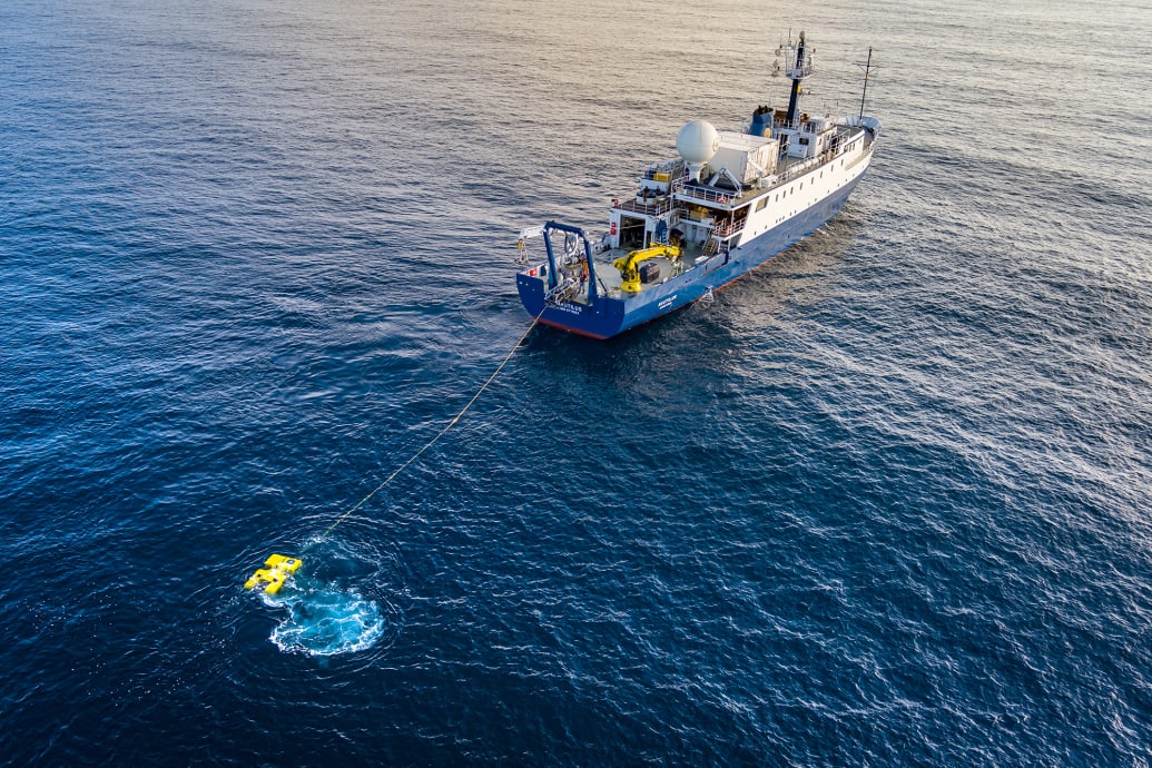
This footage, taken Oct. 19, 2019, is just a glimpse of some of the incredible sights captured by the E/V Nautilus, a research vessel charged with exploring and documenting one of the most fascinating and least explored parts of the planet: the bottom of the ocean.
On its YouTube channel, the crew of the Nautilus posts some of its greatest hits: the whale fall; a brine pool (a toxic-to-humans but vital to some wildlife naturally occurring pocket of highly salinated water); a garden of over a thousand octopuses solemnly guarding their fertilized eggs; and the rusted hulk of World War II German submarine U 166, sunk in the Gulf of Mexico.
As gorgeous and fascinating as these scenes are, the Nautilus’ most important work is less visually exciting but could be far more consequential. As of 2022, less than a quarter of Earth’s ocean floor has been properly mapped. A project known as the the Nippon Foundation-GEBCO Seabed 2030 Project, which is composed of two nonprofits, is working to slowly fill the gaps and completely map the entire ocean floor by the end of the decade. The data is coming from a number of sources, including world governments and their militaries, private corporations, and of course the Nautilus and other research vessels.
For the scientists helming this project, Seabed 2030 is not merely an adventurous journey to know what kind of hidden gems are laying at the bottom of the ocean (whether it’s geological marvels, ecological peculiarities, or man-made relics). A better understanding of how the planet’s climate is changing is at stake—and with that, the potential to save many more lives from suffering and preventable hardships.
Usually, the Nautilus accomplishes its mapping using a technique familiar to anyone who’s ever watched The Hunt For Red October: sonar. By sending sound deep into the water and calculating how long it takes to return, a picture can be drawn of the depth and ocean floor topography. Sonar also picks up what’s called backscatter, which is the intensity of the returning sound. Since different materials like rock, sand or coral absorb different amounts of sound, backscatter can help researchers determine what types of habitats might be located in different locations.
On previous voyages, the Nautilus had been the sole source of sonar signals. But that’s changed for a three-week trip that began June 15 to explore the Papahanaumokuakea Marine National Monument, a 583,000-square-mile stretch of ocean, atolls and islands in the Pacific near Hawaii. The crew brought along a new toy: an unmanned surface vehicle called DriX, to be sent into shallower waters with its own sonar array.
“The general path things are evolving in is we’re doing a lot more with robots and using autonomous vehicles,” Daniel Wagner, the lead scientist for the Ocean Exploration Trust (the nonprofit that runs the ship), told The Daily Beast. “So that’s a commitment that we’re trying to do over the next couple of years, is testing some of these emerging technologies.”

Mapping the ocean floor is not a new idea. Mariners looking to keep their ships from running aground in shallow water have noted obstructions since man took to sea. In the 18th century, ship crews were noting depth by throwing rope anchored by lead overboard and seeing how far they sank. By the 1930s, sonar was already being used to make rough outlines of the ocean floor. The work was expanded on by figures such as pioneering geologist Marie Tharp, whose map of the Atlantic Ocean was critical to helping scientists accept the theory of plate tectonics (which suggests the Earth’s outer crust is made of giant plates that have been moving around for billions of years).
Those early efforts used technology that was in its relative infancy. More recently, satellite arrays have also been used to draw a clearer, but still fuzzy picture. To date, just 23.4 percent of the ocean floor has been mapped using modern-day sonar.
There are existing maps of much of the ocean, but they are incredibly low resolution, according to Vicki Ferrini, a senior research scientist specializing in deep sea mapping at Columbia University’s Lamont-Doherty Earth Observatory and head of the Atlantic and Indian Ocean portion of the Seabed 2030 mission.
“Once you go and map it with a ship, there’s like, a mountain that wasn’t there. So there’s incredible detail that’s just lacking.”
— Vicki Ferrini, Columbia University
“Once you go and map it with a ship, there’s like, a mountain that wasn’t there. So there’s incredible detail that’s just lacking,” she added.
While the new maps will be much more accurate, they won’t exactly set up a Google Maps for the ocean floor. Instead, it’s dividing the ocean into grids. In the shallower areas, grid cell sizes will be 100 meters on each side—roughly the size of a soccer field. At its deepest points, the resolution will be down to 800 by 800 meters.
What exactly is the point of mapping the ocean floor? There are, in fact, practical motives. It’s vital to know where obstructions are located when laying down fiber optic cables or building underwater natural gas pipelines. Safety and navigation depend on knowing what’s underwater—Ferrini, for instance, wonders whether the remains of Malaysian Airlines Flight 370, which mysteriously went missing in 2014, would have been found if accurate ocean bed maps had been available to search teams. An accurate map also helps us better predict where water-based life can be found, which could be a huge boon to commercial fishing.
But for many of the scientists involved, the mapping project’s more critical role has to do with learning how our climate works—and how it’s changing. The shape of the ocean floor has a gigantic effect on how the water actually circulates, which in turn affects many of the components that affect how the planet’s climate actually operates such as wind patterns and tides.
For instance, knowing the topography of the ocean floor gives scientists a better understanding of cold and warm water currents across the planet. These currents are the cause of weather phenomena like El Niño, which can affect everything from flooding in the Southeast U.S. to the depletion of fish stocks thanks to a lack of phytoplankton rising from the bottom.

The Nautilus “control van” where the crew controls and oversees its remote vessels.
OET Nautilus Live
Better data leads to a better model for how the global climate operates, which means better predictions for how that will change as humans continue to emit greenhouse gases.
That, in turn, can help us make better predictions for how communities around the world ought to prepare themselves against fiercer storms, worse floods, hotter summers, and crueler winters—potentially saving lives in the process.
“Understanding the shape of the ocean is a really important factor for understanding the magnitudes of certain things, like the way tsunamis and typhoons travel [depends on what] the topography underneath them is,” said Wagner.
Still, all of that is only possible if the project overcomes its myriad of challenges. The parties involved in Seabed 2030 have to voluntarily hand their data over to the project. Not every party, especially those affiliated with national militaries or secretive private companies, is interested in doing so.
Another issue is much more obvious: Oceans are really, really big— covering almost 140 million square miles. Observing that much ground by 2030 is a tall order.
But there is confidence it will get done. The years between 2020 and 2030 have been dubbed the “Decade of Ocean Science For Sustainable Development” by the UN. Technologies like DriX could propel the development of autonomous robotic ships that traverse the ocean.
Until then, ships like Nautilus will slowly chip away, doing its part for the larger mission and capturing some amazing footage in the process.
“Pretty much every single dive there’s something new. We find things that hadn’t been found, either a species that we didn’t know, or it’s a species that we didn’t know existed there,” said Wagner. “When most people think about the deep ocean, they think of a dark emptiness, that there’s nothing there… A lot of people, they would think, you can just dump trash in there and it doesn’t really have an impact, when in fact, there is a lot of life, if you look in the right places.”
[ad_2]
Source link